


Rimfire Pacific Mining (ASX: RIM) - Bogan River Licence Applications Beside the Nyngan Scandium Deposit


Rimfire Pacific Mining (ASX: RIM) has applied for two exploration licences covering 500 square kilometres next to the Nyngan Scandium Deposit in central New South Wales. This release adds new ground to the portfolio and Samso has taken the opportunity to look at what historical data exist and what they are saying about Rimfire's applications.
All prices in this piece are as at the close of ASX trading on 19 October 2026.
The Announcement
On 20 October 2026 Rimfire released “Rimfire builds its 100% owned scandium footprint” to the ASX [R1]. The company has lodged Exploration Licence Applications 7124 and 7125, which it names the Bogan River Project.
EXPLORATION LICENCE APPLICATION A request to the New South Wales government for the right to explore an area. Work on the ground can only start once the licence is granted. |
The release places the ground immediately west of the town of Nyngan, near Rimfire’s Rabbit Trap Project, which the company also owns outright (FIG. 01). Rimfire’s Fifield district deposits, including Murga, are more than 100 kilometres to the south.

At the close on 19 October 2026, Rimfire’s 2,999,138,802 shares were priced at 1.0 cents, a market value of about A$30.0 million [R2].
Highlights
Two exploration licence applications covering 500 square kilometres, close to the existing 100% owned Rabbit Trap Project.
The ground adjoins the Nyngan Scandium Deposit, owned by Scandium International Mining Corporation.
The company says there are numerous untested magnetic anomalies, which it interprets as mafic-ultramafic intrusions similar to those that host scandium elsewhere in New South Wales.
Rimfire says the ground has seen little, if any, earlier exploration for scandium.
The company expects the licences to be granted within the next two to three months.
What the Magnetic Targets Are
Rimfire says the Geological Survey of New South Wales interprets many of the magnetic anomalies at Bogan River as Ordovician mafic-ultramafic intrusions [R1]. Rocks of this kind host the Nyngan scandium deposit next door and the Fifield deposits more than 100 kilometres to the south.
MAFIC-ULTRAMAFIC INTRUSIONS Bodies of dark rock, rich in iron and magnesium, that cooled from molten rock below the surface. Ordovician means they formed roughly 485 to 444 million years ago. They often carry magnetic minerals, so they tend to show up on an aeromagnetic image, a survey flown by aircraft that maps small changes in Earth’s magnetic field. |
The release places them in the Fifield Intrusive Suite, a belt of Alaskan-Ural style intrusions that runs several hundred kilometres north to south along the margin of the Macquarie Arc in central New South Wales. The style is named after similar intrusions in Alaska and the Ural Mountains of Russia. Rimfire sees the Bogan River intrusions as similar to those that host the scandium deposits at Fifield.
Rimfire has outlined its targets in red on its aeromagnetic image (FIG. 02), and Samso counts ten. The release says the most recent holders of the ground were looking at carbon sequestration, which means storing carbon dioxide in the ultramafic rock, and that the project has seen little, if any, earlier exploration for scandium.
The release points to the Nyngan Deposit next door, where shallow scandium in the weathered top of the rock overlies one of the magnetic anomalies. Rimfire says this “reinforces the scandium prospectivity” of Bogan River. The release also describes the town of Nyngan as a regional centre with major roads and a rail network.


The Nyngan Deposit Next Door
The Bogan River ground is next to the Nyngan Scandium Deposit, owned by Scandium International. Nyngan is well studied, with a resource, a reserve and a definitive feasibility study behind it.
SCANDIUM INTERNATIONAL Scandium International Mining Corporation is listed in Canada. Its Nyngan titles are held on the state register by EMC Metals Australia Pty Ltd. The release calls it “TSX – listed” in the highlights and lists it on the TSX-V under the code SCY in the introduction. The company’s website lists it on the TSX Venture Exchange [R3]. |
At Nyngan the scandium is in clay. The release says it is in the weathered top of the Gilgai Intrusion (Whitbarrow Creek Ultramafic Complex), a body of pyroxenite and olivine pyroxenite. Most of the scandium is in the limonite and saprolite layers. The weathered profile can extend more than 60 metres deep, and it is covered by 8 to 40 metres of sediment from the Bogan River floodplain.
LATERITE, LIMONITE AND SAPROLITE The weathered top over the rock is called a laterite, a layer rich in iron and clay that forms over a long time in a warm, wet climate. Limonite is an iron-rich clay layer below the haematitic clay at the top. Saprolite is the softer weathered rock beneath it. |
TABLE 01 sets out Nyngan’s resource and reserve as Rimfire quotes them [R1]. The resource is 16.92 million tonnes at 235 ppm scandium, in the Measured and Indicated categories. The reserve is 1.43 million tonnes at 409 ppm.
RESOURCE, RESERVE AND PPM A Mineral Resource is an estimate of the scandium in the ground, and Measured and Indicated are its two more confident categories. A Mineral Reserve is the part that at least a pre-feasibility study shows can be mined economically, and Proven and Probable are its categories. Ppm means parts per million, the same as grams per tonne. |
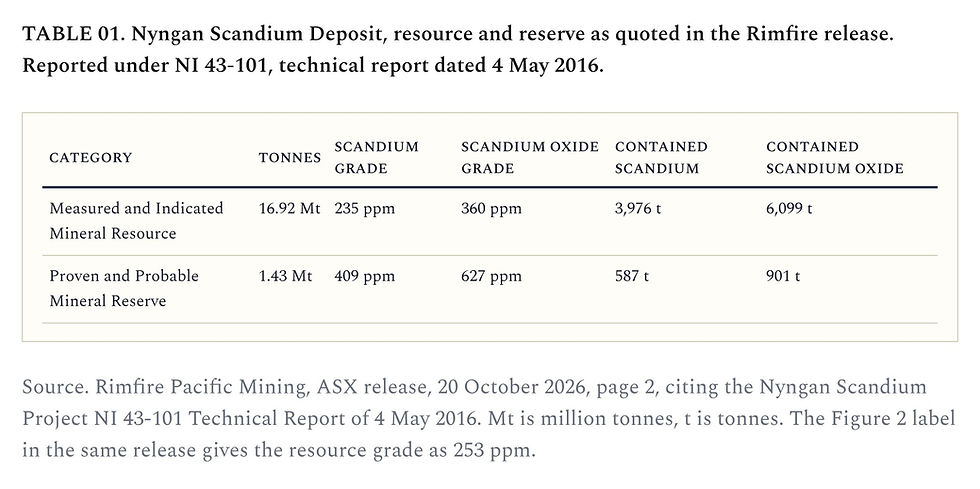
These figures come from a technical report dated 4 May 2016, prepared under NI 43-101, the Canadian reporting standard, rather than the JORC Code used on the ASX. The release gives the resource grade as 235 ppm in its text and 253 ppm on the Figure 2 label.
Scandium International is now updating its 2016 definitive feasibility study for Nyngan, according to its June 2026 release [R4]. The 2016 study planned to treat about 75,000 tonnes of limonite ore a year and produce about 38.5 tonnes of scandium oxide a year. It used less than 20 per cent of the resource, at an average head grade of 409 ppm, the same grade as the Reserve [R4].
DEFINITIVE FEASIBILITY STUDY The most detailed study of a project, done before a decision to build a mine. |

What Samso Found in the Old Exploration Reports
Samso has read the historical open-file reports (Geological Survey of New South Wales library, called DIGS) that cover parts of the Bogan River ground [R5] and plotted every known drill hole against Rimfire’s targets.
No report holds a scandium assay from inside the two applications, supporting the release, which says the ground has seen little, if any, earlier exploration for scandium. Scandium was not unknown here. Jervois Mining, Platina Resources and New Age Resources each named it as a target over parts of the ground between 2010 and 2023, although none of them sampled or drilled for scandium inside. The work that was done would have been mainly desk studies, with one site visit and one roadside photo traverse [R5].
FIG. 03 shows Rimfire’s ten target outlines, traced by Samso from the release’s Figure 2, on the state magnetic image with the drill holes on top. Fourteen drill holes are recorded inside the applications. On the recorded positions, four of the targets have one hole each and six have no known hole. One of those six appears to lie almost entirely outside the applications on the state register, although Rimfire’s Figure 2 draws it inside. Four more Helix holes plot just outside T10, on positions the state database calls a best estimate. Whether these holes missed any "potential" targets is yet to be proven.


BHP drilled hole N1 in 1984 on a magnetic and gravity high. Under 67 metres of clay and sand it hit ultramafic rock, which BHP’s petrologist described as altered pyroxenite or peridotite. Magnetite and ilmenite made up as much as 30 per cent of some chips. BHP concluded the hole had found the source of the anomaly [R5]. Pyroxenite is the same family of rock that hosts the scandium at Nyngan. BHP was looking for platinum, gold and base metals, so it never assayed for scandium.
So the old record does not show scandium at Bogan River, and it also does not rule it out, which is what could be the potential as management narrates. From our reading, at least one target has the same family of rock as the host at Nyngan, and nobody has yet tested it, or any weathered profile on top of it, for scandium. Most of the old holes were open holes sited on magnetic peaks for other metals.
The record also tells us what Rimfire will be working with. Only N1 of the four holes on targets hit ultramafic rock. The others ended in diorite, a weathered intrusive rock and metasediment. One hole on a target of about 5 to 32 square kilometres, by Samso’s measurement, tests a single point, so these results do not rule a target in or out. The cover is deeper than at Nyngan, at 67 to 145.5 metres in the three target holes that measured it, against 8 to 40 metres next door. N1 logged 4 metres of weathered ultramafic rock and no laterite, so the weathered profile is something the new drilling will need to find.
On the state magnetic image, the strong high under the Nyngan deposit stays within the titles held by EMC Metals Australia for Scandium International. Jervois gave up EL 7664 next door because the scandium magnetic anomaly “does not extend into EL 7664” [R5]. Rimfire interprets its targets as intrusive bodies separate from the one under Nyngan, so each one will stand on its own results.
The scandium at Nyngan was first found by going back to old samples. Jervois found it in old drill core, then had the stored pulps from Anaconda’s 1999 to 2001 nickel holes assayed, and many showed scandium enrichment [R5]. That route is not open at Bogan River, because the state database records no core or cuttings kept for any of the 13 holes it lists inside the applications [R6]. The scandium test there will come from new drilling.
PULP The fine powder left after a drill sample is crushed and ground for assay. Explorers sometimes keep it in storage. |
What Comes Next at Bogan River
The two applications have to be granted first, and the release expects grant within two to three months. Application for land access will need to follow from the granting.
Six of the targets have no known drill hole, and the four that have one were drilled for other metals. That leaves the scandium question open on all ten. A magnetic high tells us where the magnetic rock is likely to be. What we still need to know is whether a scandium-bearing laterite has formed on top of that rock, and how thick and how rich it is. Only drilling will answer that, and with the cover seen in the old holes on the targets, the drilling is likely to go deeper than at Nyngan.
Being next to Nyngan is a good starting point. It usually means the right geology is close by. The grade at Bogan River will come from Rimfire’s drilling.

Leadership Commentary
Executive Chair Bronwyn Barnes said in the release [R1].
“Expanding our 100% owned projects in Australia’s scandium epicentre supports our strategy of building a globally significant scandium inventory within the region.”
She also described the applications as “a low-cost entry point for shareholders” and said demand for scandium is growing across advanced manufacturing, AI data centres, defence and aerospace.
Near-term Milestones to Watch
Grant of the two licences applied for under Exploration Licence Applications 7124 and 7125, which Rimfire expects within two to three months.
Compilation of earlier exploration data, then target generation and geophysical modelling to rank the targets for drilling.
Talks with landholders on access, which the release says start after grant.
Results from the expanded Murga leach tests, which Rimfire set out in its 28 September release and Samso covered in Murga scandium leach tests.
The update of the Nyngan feasibility study by Scandium International. Its June release gave no completion date.
Samso Concluding Comments
What this release adds is more exploration upside to the Rimfire story. As we all know in exploration, potential does not always lead to a resource. It does add another chapter, because Rimfire now holds applications next to known mineralisation that already has a resource, a reserve and a feasibility study behind it. For readers who have followed Samso, this is the kind of potential an exploration story is built on.
The release highlights that Bogan River, once granted, and Rabbit Trap are 100 per cent Rimfire’s. Rimfire would keep all of any discovery on that ground.
Nyngan gives a sense of the potential upside for Rimnfire by adding the element of a nearology play with mineralisation potential in the area. Its Measured and Indicated resource holds 6,099 tonnes of scandium oxide. That is about half the 12,000 tonnes Rimfire labels for Murga on its regional map, a whole-deposit figure (FIG. 04). Rimfire’s share depends on the partner’s earn-in at Fifield. The two are not alike. Murga’s resource is Inferred, at 138 ppm scandium under the JORC Code. Nyngan’s is Measured and Indicated at 235 ppm under the 2016 Canadian code. The comparison is a guide to size only.

From here, Bogan River needs the licences granted, the targets drilled through the cover, and a weathered profile that carries scandium at a useful grade.
THE OTHER WAY TO READ THIS Rimfire has a market value of about A$30.0 million and an active test program at Murga. Each new project spreads the same people and the same money across more ground. Licence applications are cheap to lodge, and a regional map with more ground on it can look like progress before any drilling has been done. On this reading, the next set of Murga results is more important to shareholders than another 500 square kilometres. The cover also adds cost. Where the old holes on the targets measured it, the cover is 67 to 145.5 metres, against 8 to 40 metres at Nyngan. Drilling through that depth costs more per hole than at Nyngan, and the money comes from the same budget as the Murga work. This box is Samso’s counterpoint. |
SAMSO TAKE Bogan River is a ground position next to a deposit that has been studied for more than ten years. Its owner is now updating that study. If the Bogan River intrusions do carry scandium in their weathered profile, would that ground be more valuable to Rimfire as its own project, or as a source of ore close to whichever processing plant is built first in the district? |
Previous Samso Coverage of Rimfire Pacific Mining
Every earlier Samso post on Rimfire, newest first, with the two Samso Insights on the scandium market.
RIMFIRE PACIFIC MINING
9 OCT 2026
The 15-week leach recoveries at Murga and the scandium market after them.
30 SEP 2026
The expanded Murga metallurgical program and its timetable.
11 AUG 2026
Bronwyn Barnes becomes Executive Chair, and the A$2.3 million raising.
30 JUN 2026
Why the low iron content at Murga may point to a lower-cost leach.
15 JUN 2026
The partner vests 40 per cent of Avondale, and the Fifield seismic survey.
14 MAY 2026
The Fifield district position and the Murga leach pathway.
14 APR 2026
The upgraded Murga Mineral Resource.
SAMSO INSIGHTS ON SCANDIUM
28 AUG 2026
Scandium prices, supply and the projects that are only announced.
6 APR 2026
What scandium is used for and why its market is small.
THE VOCABULARY, IN PLAIN ENGLISH Exploration licence application A request to a state government for the right to explore an area. No work on the ground is allowed until the licence is granted. Aeromagnetic survey A survey flown by aircraft that records small changes in Earth’s magnetic field. Magnetic rocks show up as highs. TMI_RTP The label on the release’s Figure 2. Total magnetic intensity, reduced to the pole, a standard way of processing magnetic survey data so that each high lies over the rock that causes it. Mafic and ultramafic Dark igneous rocks rich in iron and magnesium. Pyroxenite is an ultramafic rock. Intrusion A body of molten rock that cooled and set below the surface. Ordovician A period of geological time roughly 485 to 444 million years ago. Laterite A weathered layer, rich in iron and clay, formed on top of rock over a long time in a warm, wet climate. Limonite and saprolite Two layers in a laterite profile. Limonite is the iron-rich clay higher up. Saprolite is the softer weathered rock beneath it. Ppm Parts per million, the same as grams per tonne. Mineral Resource An estimate of the metal in the ground. Measured and Indicated are its more confident categories. Mineral Reserve The part of a resource that at least a pre-feasibility study shows can be mined economically. Proven and Probable are its categories. NI 43-101 The Canadian standard for reporting mineral projects. ASX companies report under the JORC Code instead. Definitive feasibility study The most detailed study of a project, done before a decision to build a mine. Competent Person The qualified professional who signs off on the technical information in an ASX release. Open-file report An explorer’s report to the state government. It becomes public once the licence it covers is given up. Pyroxenite and peridotite Ultramafic rocks made mostly of the minerals pyroxene and olivine. Diorite A grey igneous rock of intermediate composition, between granite and the mafic rocks. Metasediment A sedimentary rock changed by heat and pressure. Pulp The fine powder left after a drill sample is crushed and ground for assay. Explorers sometimes store it. |
References and sources
Each source carries an identifier, [R1] to [R6], which appears in the text where the source is used. FIG. 01 and FIG. 02 are reproduced from the Rimfire release. FIG. 03 is a Samso map of Rimfire’s targets, traced from the release’s Figure 2. FIG. 04 is a Samso chart of the labels on Rimfire’s Figure 1.
Cover photo. Bogan River aeromagnetic image, Rimfire Pacific Mining, ASX release, 20 October 2026, Figure 2, page 4.
 The Samso Way – Seek the ResearchHere at Samso, we pride ourselves on delivering content for investors that is independent and informed by over three decades of experience in the industry. Our content is well-researched and is only created if I see merit in discussing the company's story. Our mission is simple. Cut through the noise and spotlight what matters. Genuine stories, grounded insights, and real opportunity. Investors can explore our four core platforms: There may be numerous paths to success in investing, but the common thread among successful individuals is that they remain committed to making informed decisions. Equip yourself with the right knowledge and tools, and you will be well on your way to achieving your financial goals. Most importantly, investors need to be absolutely diligent in understanding their own risk-reward tolerance and capabilities. Never bite off more than you can chew. As they say, Rome wasn't built in a day, and the Great Wall stood because it took centuries to complete. The Samso Philosophy: Stay curious. Stay sharp. And remember, digging deeper always uncovers the real value. In Life, there is no such thing as a Free Lunch. Never bite off more than you can chew is my parting comment. Happy Investing, and the only four-letter word you need to know is DYOR. To support our independent work, please head over to our Support Page and give us a helping hand in any of the ways listed. This is a new initiative for the Samso Platform, and it was always the concept of Samso when we started this journey in 2018. DisclaimerThis article is general information only. It is not financial product advice and it does not take into account any reader's objectives, financial situation or needs. It contains no price targets, no valuations and no recommendation to buy, hold or sell any security. Companies named in this article are used as historical illustrations of events that have already occurred and no view is expressed on their current merits. Readers should consider obtaining advice from a licensed financial adviser and should conduct their own research before making any investment decision. Samso and its associates may hold interests in companies mentioned. About SamsoSamso is a trusted platform that equips dedicated investors with up-to-date industry knowledge and insights from top CEOs and thought leaders. By staying informed on business advancements and market trends, investors can enhance their financial decisions through a combination of expert guidance and their own research. Coffee with Samso, Samso Insights, Samso News and Samso Research are four ways into the same work. Interviews, long-form research, short takes on announcements and company-specific studies. Every one of them is about how to think about investing rather than what to buy. Samso Insights | www.samso.com.au | An Investor Lens on ASX-Listed Companies Samso News is independent research commentary for general information only. Nothing in this article is financial product advice, and it does not take into account any reader's objectives, financial situation or needs. Figures are drawn from public sources believed reliable at the stated dates but are not guaranteed; market-sensitive numbers change daily. Samso or associated parties may hold positions in, or have commercial arrangements with, companies mentioned. Seek professional advice before making investment decisions. © Samso 2026 · samso.com.au |

Comments